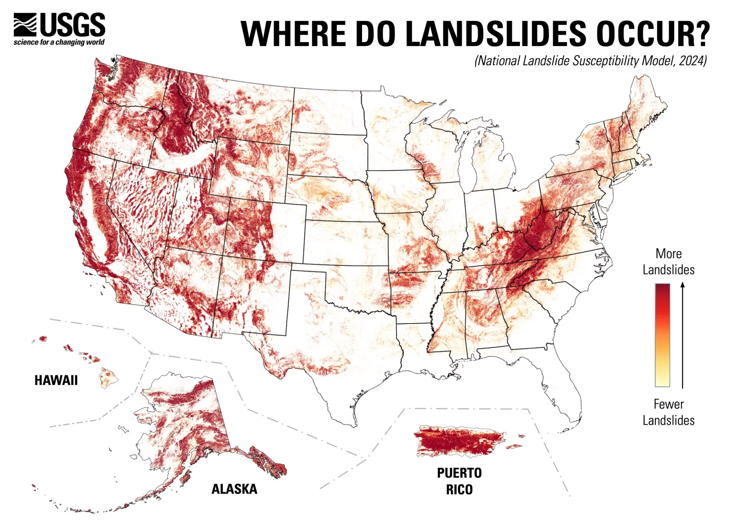
The release of the U.S. Geological Survey’s (USGS) nationwide landslide susceptibility map marks a significant advancement in understanding geological hazards across the United States. Covering nearly 44% of the country, this map provides a granular view of landslide risks, highlighting both areas of concern and those that are less susceptible. The groundbreaking assessment not only sheds light on the prevalence of landslides but also serves as an essential tool for risk management and land-use planning. By mapping these hazards at the county level, stakeholders can make more informed decisions about where to develop, protect, or strengthen infrastructures.
Utilizing cutting-edge technology, the USGS’s efforts have integrated high-resolution elevation data and nearly one million historical landslide events to create a detailed susceptibility model. This leverages advanced computing and extensive datasets that were previously unavailable or underutilized. The resulting high-resolution map provides a more precise identification of landslide-prone areas compared to earlier models that only covered specific high-risk locations. As a result, Americans can better prepare for potential risks and ensure that emergency services, planners, and engineers have the necessary information for mitigating disaster repercussions.
The implications of this new map extend far beyond individual preparedness. Urban planners and local governments can now adopt a proactive approach to land-use by prioritizing regions with a higher susceptibility to landslides. This proactive measure can lead to smarter zoning laws, the re-evaluation of existing structures, and more informed community planning. The detailed insights provided by the map are invaluable for developers and engineers, who can integrate these findings into project designs to minimize future risks associated with landslides.
Mirus also emphasizes the importance of community-level awareness, stating that public access to this knowledge fosters a “hazard-ready nation.” This awareness can drive community engagement and education efforts, encouraging local residents to understand their environment and take appropriate precautions.
Future Directions and the Need for Continued Research
While the new landslide susceptibility map is a remarkable tool, it also signals the need for ongoing research and updates in the field of geological hazard assessment. As climate change continues to alter weather patterns—the leading contributor to landslides—there is an urgent need for continuous monitoring and modeling efforts. The map can serve as a baseline, from which updates and refinements can be made to incorporate changing environmental conditions more effectively.
The USGS’s nationwide landslide susceptibility map represents a vital step toward a more comprehensive understanding of geological hazards in the United States. By empowering planners, engineers, and communities with better data, the potential for disaster preparedness is enhanced, ultimately contributing to a safer and more resilient nation. The hope is that this innovative tool serves as a foundation for future research and adaptation in areas susceptible to landslides, ensuring that all stakeholders can effectively respond to these natural threats.


Leave a Reply