
Nitrogen dioxide (NO2) is often a silent aggressor against air quality and public health. This harmful pollutant, primarily generated from the combustion of fossil fuels in vehicles and power plants, poses serious hazards to the environment and human well-being. At a glance, nitrogen dioxide is a critical player in the development of smog and respiratory ailments, with its characteristic yellow-brown coloration acting as a visible reminder of its presence in our atmosphere. Given the widespread implications of elevated NO2 levels, it is crucial to develop effective monitoring techniques that can precisely identify and quantify these emissions. Enhanced detection is essential not only to mitigate air quality challenges but also to formulate actionable policies aimed at reducing pollution exposure.
Historically, satellites like the Copernicus Sentinel-5P have enabled researchers to map NO2 concentrations from space, but these technologies often wield a spatial resolution that remains too coarse to effectively pinpoint specific emission sources. Relying on averaged data across broad regions has proven inadequate in urban settings, where pollution sources can be densely packed together. Thus, until recently, identifying emission hotspots or attributing pollution levels to specific power plants felt like an impossible feat, leading to ambiguity in accountability and response measures.
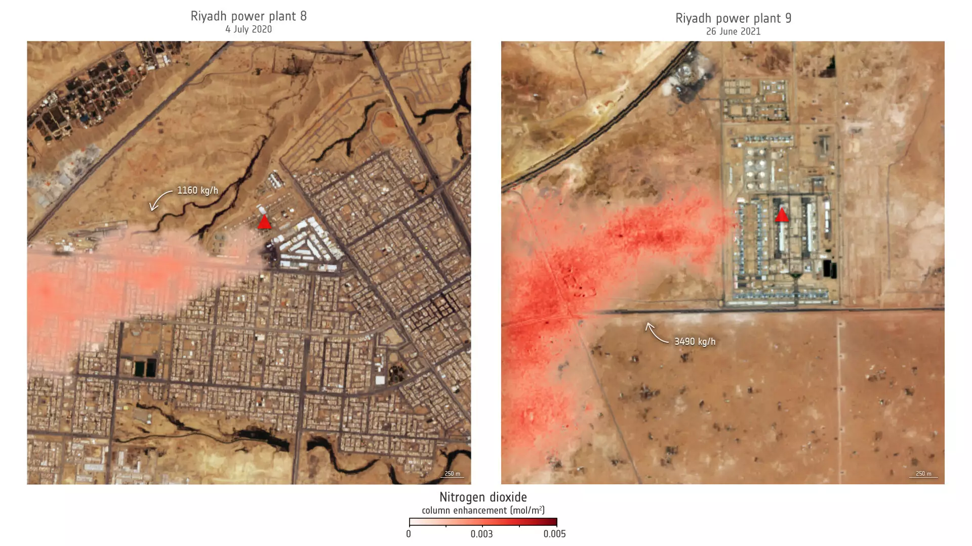
In a remarkable advancement recently documented in the Proceedings of the National Academy of Sciences, researchers have harnessed imagery from Copernicus Sentinel-2 in conjunction with U.S. Landsat satellites to monitor nitrogen dioxide plumes with unprecedented accuracy. Unlike its predecessors, Sentinel-2 was designed to capture high-resolution images that often focus on land use, vegetation, and water bodies. This strong spatial resolution now proves valuable for scrutinizing atmospheric pollutants. Notably, this newfound capability transforms the Sentinel-2 satellite into an essential asset in the ongoing battle against air pollution—one that still has the potential to evolve.
Researchers have utilized the blue and ultrablue bands of Sentinel-2 and Landsat imagery, meticulously identifying NO2 emissions from power plants in regions as diverse as Saudi Arabia and the United States. This innovation signals a paradigm shift in how we approach environmental monitoring, granting us tools that can detect pollution sources at a level of detail that has eluded scientists for decades.
A key finding in the research emerges from a comprehensive analysis of emissions from power plant 9 in Riyadh, Saudi Arabia. Over a period spanning from 2009 to 2021, emissions exhibited significant seasonal variations, peaking during the summer months when air conditioning usage swells. The critical observation that emissions mirror human behavior raises questions about our reliance on fossil-fuel-driven energy sources during peak usage times. This nuanced perspective makes clear that effective air quality management must also consider contextual factors such as local climate and infrastructure demands.
With insights extracted from high-resolution imagery, a clearer picture of how power plants influence nitrogen dioxide emissions is now possible. The ability to monitor and track emissions from specific facilities allows policymakers to direct interventions and hold corporations accountable for their environmental impact.
The technological breakthroughs are not without their caveats. Research lead Daniel Varon has articulated concerns regarding operational performance, particularly in areas marked by complex terrain or dark surfaces where satellite detection may falter. These limitations underline the importance of integrating satellite data with ground truth measurements and traditional monitoring networks. Nevertheless, the advantages of employing high-resolution imagery in air pollution assessments are formidable, offering a promising tool to untangle complex air quality issues.
The advancements in high-resolution satellite monitoring represent a significant leap forward in our ability to tackle the challenges posed by nitrogen dioxide and other pollutants. The upcoming Sentinel-2C, scheduled for launch in September 2024, is poised to enhance this capability even further, reinforcing the mission of providing continuous and detailed data essential for rigorous environmental monitoring.
In a world beset by climate crises and rapidly deteriorating air quality, the implementation of these advanced satellite technologies affords us a proactive stance. They empower researchers and policymakers to decode the nexus between emissions and public health, ultimately guiding us toward more robust, data-backed solutions to combat air pollution. In bridging the gap between technological possibility and environmental responsibility, the future of air quality monitoring looks brightly optimistic.
Leave a Reply